 |
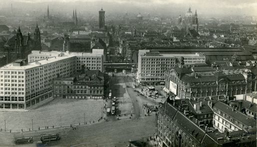
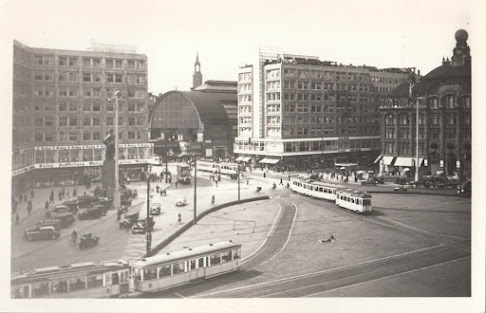
| Above, the Alexanderplatz area today. Below, the same in 1940. |
It is a hard task to imagine a place which no longer exists. In Alexanderplatz' case, nearly everything has changed and it is impossible to picture for yourself Franz Biberkopf walking across the square from Saturn Electronics to Five Guys to have a bite.
But if you still insist in reconstructing the old Platz for yourself, I suggest that you take as a starting point the two Peter Behrens' buildings, the Berolinahaus and the Alexanderhaus, as they are still at the same place where they were built back in the 1930s. Looking at them, you'll have the same view as you would have had in those years. The two buildings were and still are the south-eastern border of the Platz. When they were built they were seen as gatehouses, as the entry to Eastern Berlin.
Another elements that hasn’t changed, not its position anyway, are the elevated S-Bahn and the train station ; they are behind the Platz, running parallel to the two buildings, along the Dircksenstrasse, in direction NW-SE.
The outer limits of Alexanderplatz are today four streets : Alexanderstrasse, Karl-Liebknecht Strasse (the former Kaiser-Wilhelm-Strasse), Grunerstrasse and Dircksenstrasse. But those streets delimit a surface of about 400x300m. Alexanderplatz was not that large. Besides, other places are often attached to Alex without actually being a part of it: the esplanade between the Spree and the S-Bahn station, including the Marx-Engels-Forum, the Marienkirche, the Rotes Rathaus and the TV-Tower.
 |
| Source: OpenStreetMap |
On the map above, the roughly rectangular area marked with red lines shows the Alexanderplatz during the Weimar era. It is about 150x100m. And it is more or less the same area as today’s Platz. During the GDR period however, it was much larger, as not all the destroyed buildings had been replaced by new ones. But our days’ Alexanderplatz is about the same size as the old one. The street names in red show some of the streets and places that have disappeared.
Adding to the confusion is the fact that some streets have disappeared altogether, making a pedestrian area of the whole square, all traffic except the trams having been diverted to large surrounding multi-lane avenues (Karl-Liebknechtstrasse, the new Alexanderstrasse). Königsstrasse, which once run SW-NE between Berolinahaus and Alexanderhaus, is one of the extinct arteries. But if Königstrasse, which divided the square in two parts, is gone, the rails of the tramway are still there, as in the old days, as a reminder of the obliterated street.
Alexanderstrasse is a confusing name. When the large Tietz department store was in place (where Galeria Kaufhof stands today), Alexanderstrasse run on its NE side, parallel to the line of the elevated railway. Tietz had what was considered the world's longest facade along that street (250m). But today there is no street there. A very large avenue called Alexanderstrasse runs some 100 m to the NE but it has only the name in common with the old street.
The Rote Burg, the Polizei Präsidium or Police Department, was also destroyed during the war or in its aftermath. In its place stands the gigantic pink-coloured Alexa shopping-center, bigger than the Rote Burg had been. And the old Central Market from 1886, close to the Platz but on the other side of the railway, is but a memory.
The Georgen Kirche was never reconstructed. It stood, with the Minolhaus on its western side, in an angle formed by the Neue Königstrasse (today Bernhard-Weiss Strasse or Otto-Braun-Strasse) and the vanished Landsbergerstrasse.
But apart from those changes, everything is the same. Just joking…
 |
| Source: HistoMapBerlin.de |
The image above (by Mr. Thomas Mühlberg) is a superposition of two maps, more or less the same maps that I show separately on the first picture of this post (also from the excellent site Histomapberlin.de). Thank you Thomas!
 | |
|
Above: again a comparison between 1940 and today. Why 1940? Because I couldn't find a map from 1932 or 1925, and Alexanderplatz cannot have changed much between1932 and 1940. The map is from 1940 and the red lines show the principal roads today. The green line shows the railroad.
Enough of maps. Let's look at some photographs. I’ll try to make a sort of timeline of Alexanderplatz’ development over the years:
In 1904, it looked like above. No Behrens buildings yet, but the train station is already there, as are the tramways along Königstrasse. The famous statue of Berolina is in front of the entrance to the Tietz warehouse, built between 1905 and 1911. Behind the elevated railway there was a branch of another famous store: Wertheim.
The pic above must be from 1932 at the latest. Both Behrens 8-storey buildings, with square windows in rationalist style, are already there (Berolinahaus was the first to be finished) but we still see some old constructions just in front of the Alexanderhaus. At that place, in the southeast of the square, had once stood the Königstädter Theater, known for its popular comedies in Berlin dialect. It closed in 1851.Thereafter the building was used for wool storage, then as a tenement house, and finally as an eatery belonging to the emblematic Aschinger chain. The old building, which as we can see in the picture, looked completely out of place beside the much higher and modern Alexanderhaus, was demolished in 1932. As for the Berolina statue by Tietz, it was taken away in 1927 during the works of the U-Bahn.
Above: we are now sometime after december 1933, the moment when the Berolina statue was reinstalled, not by the Tietz entrance but on the other side of Königstrasse, in front of Alexanderhaus, where the old constructions had stood until 1932. From left to right we see the Alexanderhaus, the S-Bahn station, the Berolinahaus and the Tietz department store. In the middle of the square there is also an oval traffic roundabout, designed by Martin Wagner.
This is how Alexanderplatz looked the day the bombings started, in 1944 or 1945. And if you overlook Tietz and the Berolina statue, and the fact that the tramways run on a street (Königstrasse) and not just across the square as they do today, it is more or less how it looks now, seen from this angle.
 | |


a good summary sahib. go back a bit further and you've go alex as a battleground! back in 1919, there were clashes between rebels and government troops here. and back in 1848, the same. one of my favourite locations in berlin. i do not look forward to the latest round of redevelopments.
ReplyDeleteI concentrate on the Weimar years though 1848 is important of course. For me, 1919 is the pre-Weimar years, but a historian may think otherwise. Thanks for your comment!
Delete